- Family-friendly
- Signage
- Certified Trail
- Tour with a Dog
- "Hiking in Germany" Quality Trail
- Free of charge / accessible at any time
Rothaarsteig from Haincher Höhe to Dillenburg
The 27-kilometer hike leads from Haincher Höhe, past the source of the Dill River, the "Nase im Wind" observation deck, the Hauberg Trail, and the Lucaseiche oak tree, all the way to the city of Dillenburg, known as the "City of the Oranges."


Tour starting point:
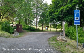
Haincher Höhe Hiking Parking Lot
Tour destination point:
Dillenburg Train Station
Properties:
Additional Information
For more information about the Rothaarsteig, visit www.rothaarsteig.de or call the toll-free service hotline at +49 2974 / 499 4163. We’d be happy to provide you with personalized advice on planning your trip.Category
regionaler WanderwegLength
27.3 kmDuration
7:20 hElevation ascent
418 mElevation descent
798 mLowest point
223 mHighest point
604 mCondition
Difficulty
Recommended seasons
The first destination on this multi-stage tour is a spring: The Dill is a 55-km-long tributary of the Lahn and forms the natural border between the Hessian Westerwald and the Lahn-Dill Uplands. After passing through Hainchen and Gernsbach (523 m), the route ultimately leads to the Tiefenrother Höhe (551 m). Here, you can enjoy spectacular views and breathtaking sunsets from the “Nase im Wind” observation deck.
After passing a small quarry, you’ll reach the 300-meter-long Hauberg Trail, which provides an informative introduction to the topic of Hauberg agriculture. This unique form of land use—a combination of farming and timber production—emerged in connection with iron smelting. After a few meters, at the “Kalteiche” trail junction, the Rothaarsteig splits. Here, the trail gradually leaves the Rothaar Mountains behind and wends southeast toward the Lahn-Dill Uplands. The main trail leads directly to Dillenburg. The Westerwald variant of the Rothaarsteig also leads to Dillenburg, but via the Fuchskaute in the High Westerwald.
On the main trail, you’ll first come across the Lucaseiche natural monument—an impressive sight at 27.5 m tall with a trunk circumference of 3.85 m. Passing the idyllically situated Steinbach forest lodge, the Rothaarsteig descends into the Dill Valley. The Westerwaldblick lookout point provides the motivation for a final ascent over the Struth, which leads down into the Dietzhölztal valley. The trail then continues over the Galgenberg (302 m) and into the “Oranierstadt” (Orange City) of Dillenburg.
Those who need to catch the last train or simply don’t want to wait any longer for a well-deserved refreshment can take a yellow-and-black-marked access trail from here directly into downtown Dillenburg. Nature lovers, however, will continue around the town of Dillenburg to the Bismarck Temple to enjoy the magnificent view of the entire town with the Wilhelmsturm tower across the way. Narrow paths lead down into Dillenburg’s Altstadt. The Rothaarsteig then leads through the Hofgarten to the train station, the trail’s endpoint.
Information
Directions
Haincher Höhe - Source of the Dill - Tiefenrother Höhe - Junction of the Westerwald and Dill routes, Kalteiche - Lucaseiche - Steinbach Forest House - Haiger-Rodenbach - Dillenburg-Manderbach - Dillenburg-Bismarck Temple - Dillenburg-Hofgarten - Dillenburg-Train Station
Equipment
The Rothaarsteig follows numerous nature trails away from agricultural and forestry roads. Therefore, weather-resistant clothing and sturdy footwear are a must for every hike. After all, we want you to experience the “Path of the Senses” not only with “dry” feet but also with “steady” ones.
In our small hiking shop at www.rothaarsteig.de/shop, you’ll also find a selection of Rothaarsteig merchandise to help you prepare for your hike or to take home as a souvenir. We’re also happy to recommend the durable, high-quality outdoor gear from our long-standing partner, the outdoor equipment supplier Tatonka.
Hiking Backpack
With the right hiking backpack, your hike on the Rothaarsteig will be twice as much fun! Hiking backpacks offer excellent comfort thanks to a ventilated carrying system, which ensures that sweat can evaporate immediately. They can be secured with a chest or hip strap, ensuring they stay firmly against your back with every movement. They’re also equipped with a practical holder for hiking poles and often feature a compartment with a hose outlet for a hydration bladder, ensuring you stay hydrated at all times. Here you’ll find hiking backpacks from the outdoor gear manufacturer Tatonka in various sizes for day hikes and multi-day trips, featuring different ventilated back systems.
First-Aid Kit
To ensure you can fully enjoy your hike on the Rothaarsteig, it’s a good idea to pack a first-aid kit in your backpack as a safety precaution. After all, nothing is more frustrating than not being able to immediately and properly treat a blister on your foot or minor injuries. Tatonka’s first-aid kits are stocked with all the essential supplies for treating injuries and also include an “outdoor cheat sheet” with concise and clear guidelines on how to respond to emergencies in the great outdoors. Find Tatonka’s first-aid kits here!
Food and Drinks
On some sections of the trail, especially between Lahnhof and Dillenburg, there are unfortunately no places to stop for refreshments along the way. Be sure to pack food and drinks, especially for these sections. Staying hydrated is especially important in the summer. Tatonka’s stainless steel bottles, stainless steel insulated thermoses, and stainless steel lunch boxes are not only practical but also unbreakable and durable.
Safety guidelines
Information About the Emergency Signs on the Rothaarsteig
Hiking trails usually run away from towns and settlements, and anyone who hikes has surely wondered at some point what would happen if an emergency were to occur. How can I be found here? Where am I, anyway? Can emergency services reach me? But in an emergency, time is of the essence! That’s why the Rothaarsteig is equipped with so-called emergency signs along its entire length. The green-and-white plaques attached to the signposts feature a number that you must provide when making an emergency call. This allows emergency responders to know exactly where you are, saving valuable time.
Note on the Increased Risk of Wildfires
Please be aware that due to dry conditions, there is currently an increased risk of wildfires! Therefore, please observe the following guidelines:
- Comply with the legal ban on smoking in the forest—it applies in spring, summer, and fall, specifically from March 1 through October 31.
- Observe the ban on open fires in the forest and within 100 meters of the forest.
- Take any glass with you when you leave the forest—the magnifying effect of glass can trigger forest fires.
If it’s (too) late:
- Extinguish small fires as they start, if you can do so safely. If necessary, check the area carefully.
- Report fires by calling “112.”
- Leave the danger zone by the shortest route.
The forest will thank you!
Author Tip
- Dillquelle
- "Nose in the Wind" Viewing Platform
- Kalteiche
- Lucas Oak
- Steinbach Forest House
- Bismarck Temple, Dillenburg
- Wilhelm Monument, Dillenburg
- Dillenburg Palace Gardens
Accommodations:
There is no lodging directly on the Haincher Höhe. The Jokebes Inn in Irmgarteichen and the Hotel Fünf10 in Deuz offer a shuttle service to and from the Haincher Höhe upon prior reservation.
Other establishments along the route:
Literature
To help you prepare for your hike, we’d be happy to send you our free information packet. At www.rothaarsteig.de/prospekte, you can easily select the information you need. Our brochure “Rothaarsteig Guide” is a great companion for any hike, featuring accommodations along the trail and other useful information.
The Rothaarsteig recommends:
- Hikeline Hiking Guide: Rothaarsteig Long-Distance Hiking Trail —From Brilon in the Sauerland over the ridge of the Rothaar Mountains to Dillenburg
- Conrad Stein Verlag: Rothaarsteig Hiking Guide – Long-Distance Hiking Trail. Rothaarsteig from Brilon to Dillenburg by Amrei Risse
- Rother Bergverlag: Rother Hiking Guide: Rothaarsteig. Including the “Sauerland-Höhenflug” and the “Sauerland-Waldroute” by Matthias Schopp
Maps
Rothaarsteig Hiking Map at a scale of 1 : 50,000
- Divided into two sheets (North Sheet / South Sheet)
- 10th edition—up-to-date trail information
- Features marked shelters, viewpoints, bus stops, parking lots, and much more
- Free shipping from the Rothaarsteig hiking shop
Public transit
Dillenburg is easily accessible via various bus and train routes and is also connected to Deutsche Bahn’s long-distance rail network.
Unfortunately, the Haincher Höhe is not accessible by public transportation. The nearest bus service is available from Hainchen or Irmgarteichen. For more information, visit www.bahn.de. If you’re coming by car, we recommend taking public transportation at the start of your hike and parking your car at the end point. That way, you won’t have to worry about bus or train schedules during your hike.
Parking
There is a free hiking parking lot at Haincher Höhe. You can find free parking in Dillenburg at the stadium. Enter “Am Sportzentrum” into your GPS.